The Key to the Keys
Wednesday, 02.02., The Keys
"Hundreds
of tiny islands, about 45 of which are populated, are strung from northeast to
southwest and are connected by US Highway 1. Also called the Overseas Highway,
this road is built on the foundation of the FEC Railway. In many areas of the
key, it's the only road," I read a historic bit of information out of our
guidebook.
"And why did they call it key?"
"I have no clue.
But look at this bridge!"
"That must have been the former railway."
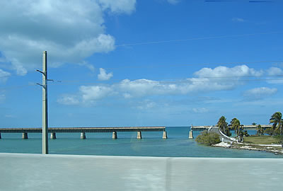
"It
looks like a Magritte painting," I said, and reached for the digicam to turn
the scene into a photo.
Half
an hour later, we crossed the Nile. It was followed by Duck Key. Then came Grassy
Key, Boot Key and - Pigeon Key.
"Pigeon? All I can see here are - Pelicans."
And
how amazing they were. Sitting on another one of those abandoned railway bridges,
ignoring the passing traffic, as this was their private resort, and us who had
discarded the pigeons.
"This bridge
is endless. I wonder how long it is," I said.
"Seven miles,"
he answered.
I stared at him.
"That at least is the name of it: Seven
miles bridge."
Watching the pelicans, I had missed the sign. Just like
I had missed the part of True Lies with the race across the bridges.
"You
really can't remember Arnie driving down these bridges?", Ronnie teased.
I
shook my head.
"The scene is endless."
"Just like this bridge."
And
it was. Endless. With a little island in the middle. And an elevation that made
you feel like driving straight into the sky, higher and higher, in ever changing
shades of blue.
Later,
on the way back, we found the answer that always had been there. Somewhere between
Sugarloaf Key and Summerland Key I browsed the paged of the guidebook again.
"In
1513, Juan Ponce de León first sailed around the Keys - 'key' is the Anglicized
version of the Spanish cayo, or cay," it said, joyfully skipping the answer
to the next question what cayo exactly means.
"Island," we decided,
and traversed the Nile again.
Map:
Florida, with our routes
next:
Meridian Crossing